Carl Hartt Fine art photography
Big Bend-White Sands-Joshua Tree-Death Valley
Blog post description.
2/15/20248 min read
Yep, “A Long and Winding Road” would be a good theme song for our latest adventure. In a nutshell, over February and March and 26 days we drove a bit over 6,000 miles thru 8 states and 5 National Parks. This email has less scenic photos than what I normally show. They are pics more of Sue in the environment. As Sue told me – this is a hiking trip, not a photo trip. And hike we did! Note too, the images have been resized significantly in order to include more pics, thus they are not very sharp and there is some pixilation.
Our first destination was Big Bend NP in southern Texas. Never been to before but I had heard good things about the place. Surprisingly, it became a NP in 1944! It follows the Rio Grande River and is a natural border (ie without a wall, LOL) between TX and MX. But it is miles or hours away from any city of decent size, much less gasoline. One thing we found rather odd was that on nearly every trail near the river there were Mexican trinkets for sale – candles, baskets, scarfs, pottery, etc. Just a jar for money, no vendor.
The park had a pretty cool exhibit of several fossils found in the area – a giant alligator (Deinosuchus) that was 30 ft long, weighed up to 11,000 lbs, had teeth 8 inches long with a jaw over 4 ft. Yep, we’d be a 2-bite snack for that beast. There was also a huge skeleton of a flying bird (Quetzalcoatlus) hanging from the ceiling with a wingspan of 35 ft. Looking up at it was unbelievable but too big to get a decent photo. Lots of other fierce dinosaur fossils too.
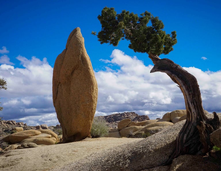
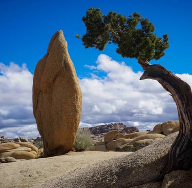
Our first hike was to Balanced Rock. We got back to the trailhead and RV in time for a spectacular sunset. Side note: sadly, we did not see any other good sunsets during the rest of the trip.
While here, we did our longest hiking day – 20 miles in a day! Yes, the next day our legs were a little sore. But we had more hiking to do the next day, so the legs did not get a chance to rest too much.
On the Lost Mine Trail in Big Bend.
We also hiked to a natural hot spring. The reason there are so many people in the pool is that one can also drive ¼ mile away from it. If you know us, we took the more scenic, 5 mile hiking route. LOL And yes, we soaked our feet.
The Rio Grande River was neat to see. Not at all what I expected of such a grand river. On the eastern side of the park (left pic), the river and valley was quite wide but had very shallow water, like knee high. The banks often had clusters of 10 foot tall grass. This made for a surreal hike. The western side (right pic) of the park the river is surrounded by very tall cliffs on each side, as expected. In each pic, Mexico is on the left, US on the right. Again, no wall.
While camping in Big Bend we saw a javelin (wild, pig-like creature) walking around, and a COW tied up at someone’s campsite. I’m not kidding! Rather odd to say the least.
After a few days here and lot of hiking, we drove across Texas and spent the night in the “viewing lot” just outside of Marfa TX. This is the notorious town with the unexplained “Marfa Lights” (Google it if need be). Yep, something is clearly out there blinking! Yet in the morning when we looked in that direction, we did not see anything other than the distant vista.
We also stopped at Marfa’s second most popular site: The Marfa Prada Store. Yes, out in the middle of nowhere. And no, you cannot buy shoes or bags here, even though they are displayed inside.
Just outside of White Sands NP is Alamogordo NM, home to several pistachio farms and stores.
At White Sands, Sue and I went “sand sledding” down the gypsum dunes (ie same stuff in plaster and drywall). The gypsum is brilliant white! The next day we met up with Sue’s sister, Cindy from Phoenix. Sue and Cindy hiked a 4 mile dune trail (lots of ups and downs) and sledded while I zigged and zagged along the dunes with my 4x5 camera. As we were leaving a sand/gypsum storm whipped up – white on white and very windy.
From here we drove over to Chiricahua (cheer a cow wa) Natl Monument in AZ. Though it is a small Natl Monument, it was spectacular. We hiked at the base of the hoodoos, through the middle of them, as well as at their tops.
From here, the three of us drove about an hour to a wildlife reserve for some free boondocking camping. We got there just after sunset. From a distance I could hear fowl honking. Sue and I went to explore, but by the time we got close to the water, it was too dark to see anything. The next morning I walked back to the water and saw thousands of Sandhill Cranes and other large water birds. While Sue was running, she saw constant flocks of birds flying off in different directions. Seeing and hearing thousands of cranes is special, something that everyone should try to experience.
About 30 min was Bisbee AZ. An old Victorian mining town that has a large open pit mine literally on the edge of town. Weird.
We then went to Tombstone, an Old West town. Dirt roads, wood plank sidewalks, pretend cowboys and lots of period saloons (ie, not bars). Kids would love this town.
We then stopped at a small hummingbird sanctuary. Unfortunately, the hummers were still wintering further south. We only saw 1.
We then spent a few days with Cindy at her place in Phoenix.
We then journeyed on to Joshua Tree NP in CA, but Cindy stayed back in PHX. I have been here before, Sue had not. Sue had a blast scrambling over all the jumbo rocks!
Note the size of the palm tree compared to Sue!
I was a little disappointed that the NP put the Heart Rock on the maps as well as created a trail to it. Now it is a very popular photo-opp. I liked it better when nobody knew and you had to explore off trail. Now I can no longer share this little hidden gem, alone, with Sue. Thanks Instagram. Oh well.
We had a blast in a somewhat hidden gem – Hall of Horrors. Imagine climbing thru the space between a pile of marbles – quasi slot canyon, quasi cave. That is the best description of this place. It was pretty cool. Sue really enjoyed this place. She looked all over for more places to squeeze through.
We usually don’t do tours, much less Ranger led tours. But the only way to see the Keys Ranch in Joshua Tree is to reserve a 2 hr tour spot. Only 20 people, 2 or 3 times a day.
On the Ranch, they also have an old Disney darkroom when they filmed several movies here. Unfortunately, they lost the key so I could not peek inside to see a 1940s darkroom.
From here, we bopped over to Palm Springs and walked along the Star sidewalks. I spotted Susan Hart (typo, LOL) on a star. How often do you see your name on a star? J And I had to get in the game too.
Our next night we had to drive 4 miles down an unpaved dirt/ gravel road to the Trona Pinnacles. Not very fast with our rig. Again, I have been here before but I had to show Sue. It’s like we landed on Mars.
We finally got to one of my favorite places – Death Valley NP. And even better, on my birthday!
Last August, Hurricane Hillary flooded L.A. and also dumped enough rain in DV to wash out nearly every paved and unpaved roads. Slowly the Park Service has been rebuilding and patching the roads. That said, many trails were also destroyed or vastly changed.
First stop was Darwin Falls. Yes, a waterfall in Death Valley! The hurricane rain washed out the 2.5 mile gravel road so we had to hike that. It also destroyed the pond wall and broke the overhanging tree. Compare 2014 to 2024 – no pond!
2014 2024
I took Sue to one of my favorite hidden gems in DV – the slot canyon at the second dip of the Artist’s Palette (shhh). It isn’t on the NP map - yet. Look carefully at the 2014 pic and the small triangular shadow on the bottom left of the choke stone. Can you find that from 2024? Or, compare the small indent found in the middle on the top edge of the 2024 choke stone to that from 2014. Same rock. The flash flooding from the hurricane washed out all the rocks and gravel underneath. *There is a deadly reason to heed the warnings about not being in a slot canyon when it is raining nearby.
2014 2024 2024 – looking inside
Marble Canyon had a deep winding slot when I was there 10 years ago. Again, the effects of the hurricane. Towards the bottom of the canyon is now filled with at least 3 feet of gravel! Note too the different types of rocks, esp the pic on the right: The middle is loose gravel. The left bank is an aggregate of a variety of smaller rocks embedded in one large flow of rock (all of this is rock hard solid) whereas the right bank is smooth polished marble. Explain this! Ok I will… lava flows, plate shifts, and finally, flash floods scouring smooth the marble while filling the bottom with gravel.
The below pic is from 2014 and shows a 4 ft long old hand rail and steps. Now the hand rail was by our feet and protrudes out of the gravel maybe 1 foot and the steps are buried deep, not to be seen.
2014
We then drove to old volcano and hiked along the caldera top. Yes, we are still in DV.
From there we hiked over a lot of sand dunes. See if you can spot Sue climbing to the top of a dune.
Badwater Basin is the lowest point in N America at 285 feet below sea level. This area usually has 4 foot diameter salt hexagons. The hurricane flooded the basin too and is now temporally called Lake Manly. The sign says “Boating Prohibited due to low lake levels”. Yes, a few weeks ago people were kayaking the “lake”. The summer heat (+110 F) will evaporate the water and the salt hexagons will return (see 2014 pic). This basin “floods” every 10 yrs or so.
2014
We did several other hikes in DV.
We got up early one day to see a disappointing sunrise at Zabriskie Point, along with a hundred other people. When I was here back in 2014 I caught a magnificent, magical sunrise!
2014 2024
Just outside of DV is Rhyolite, a ghost town and artist colony.
On the way home, we stopped at Petrified Forest NP for a few hikes. We both were here years ago.
See if you can spot Sue amongst the Blue Bluffs.
We also stopped and walked along the streets of Kingman AZ and Albuquerque NM along Rte 66. It brought back fond memories from our 2021 road trip!
In conclusion, 26 days and 6,000 miles of fun!
Update: 3 weeks after we got home, we drove to the bottom of Illinois to see the Total Eclipse. I saw it in St Louis back in 2017 and wanted Sue to experience it too. Across the entire path of totality was a crap-shoot with storms or clouds. Though we had planned to go ‘somewhere’ for it, we literally decided 2 days before where. We lucked out and had perfect skies!
On the way down, we stopped in Casey IL, a small town with Big things. Like a dozen or more Big things. Very cute town. We both had fun running around the town looking for the Largest ‘whatevers’.
Largest Taco Largest Rocking Horse Largest Mouse Trap
(or largest Rat)
After Casey, we drove an hour further south, right smack on the center-line of totality. But 10 miles before we got to Olney IL (which had lots of Eclipse events going on), I saw a small wayside park on the side of the 2 lane state highway. There were maybe 8 cars parked. I thought, great spot, easy parking, and no crowds to contend with when the eclipse was over. Though we did not get to walk around another small town or partake in any festivities, this was a perfect spot. About 30 minutes before T-time, there were probably 30 cars.
Sue’s cell pic is large in order for you to see the black spec of the moon inside the sun. And if you look carefully, you can see a few stars too!
Additional images coming soon
Additional images coming soon
Carl Hartt
Capturing life through fine art photography.
Fine Art Photography
carlharttphotography@gmail.com
© 2025. All rights reserved.