Carl Hartt Fine art photography
The Wave The Story
Blog post description.
9/15/20214 min read
To get to The Wave it requires driving 10 miles down a gravelly, washboarded unpaved road. If it rains, the clay become very slick that even 4-wheel drive won't help keep one on the road. And there is a good chance that in multiple places the road will wash away, leaving a steep banked fast-moving river, impenetrable to cross. Once at the "trailhead", one has to hike 4 miles, one way, without any shade or any length of established trail. Though, the hike out there really isn't that difficult - if one is accustomed to off-trail hiking. That said, lots of people do get lost or try to follow their phone's GPS or other offline maps and quickly find out why one should not rely on those items. The terrain is mostly flat, though lots of mild ups and downs and lots of small rocks to walk over. The hike is either slow through sand or ankle breaking when walking on sideway slick rock.
It is importantly to carry 4 quarts - 1 gallon - of water PER PERSON. More when it is hot. I came across several people at the trailhead with only 1 quart of water - and it was HOT out there. Sadly, I heard that the Search and Rescue team was called out for a 75-year-old single hiker. He ended up being ok, but he did a lot of illegal things and got several high-priced citations.
Needless to say, my pack was close to 30 lbs with 1 gallon of water, food, first aid kit, and my lighter Nikon camera gear (vs my typical 4x5 camera gear). I hit the trail by 7am and returned around 5pm. When I got back at the car, I would drink a quart of (warm) Gatorade, unpack, and cool off. Then I would drive the mile back to the campground to cook my dinner. Then repack my pack for the next day's adventure, try to wash up, and try not to move too fast or too much, else I would sweat more before trying to go to sleep.
It was 95 during the day (hot and sunny) and cooled down to 92 at 10pm. Rather difficult to sleep in a tent. LOL I should state that the small campground has no water, no cell service, no electric - but it's free.
I should mention that the night I got to Kanab before going to The Wave, I was camping (alone) in dispersed BLM land. There were a few other campers in the area too, probably 1/4 mile away. That is, this is not like a typical state or national park campground. Anyway, I happened to wake up at 4:20am (my regular MKE time then was 5:20am). I tried going back to sleep, trying to get on UT time, but I couldn't. Because I had cell service, I decided to catch up on emails. About 30 minutes later I heard "snoring" alternating with snarling / growling. WTF?
I have camped and hiked alone many times. I have come across rattlesnakes, tarantulas, coyotes, bears and rednecks. None of them scared me, kept me on my toes, but not scare me. But these sounds outside of my tent scared the crap out of me! Especially as they grew louder and moved from one side of my tent to the other side. I have NEVE been this f@#$ scared in my life! I believe it was a mountain lion. I probably disrupted his nightly walk along his hunting path. When I finally got out of my tent a few hours later, and during daylight, I listened to several mountain lion sounds on my phone. Yepper.
Now, on to the photographs that you came to see!
The area just outside of the Wave is called the Boneyard. Lots of weird, chambered rocks scattered around.
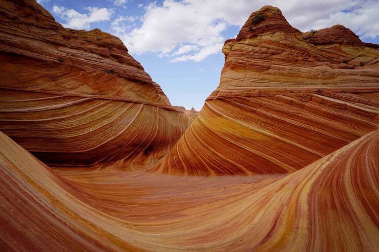
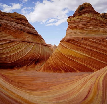
The Wave is basically a "Y" configuration. The two upper arms or branches entail almost a slot each going in different directions, whereas the base is a wider chute in which you get to take it all in and see the classic view.
The next 3 pics are of the upper branches.
This is called the Second Wave.
If you climb above the Wave, you come across lots of colorful hoodoos.
Not your typical view of the Wave, but I got a kick getting this composition. Rather hard to do considering the angle of the rocks that I was standing / balancing on.
Iconic view of The Wave. I included people in this shot in order to give you a better sense of scale. And yes, I have this shot without people too!
From the Wave Trailhead, the main wash trail leads to Buckskin Gulch, the world's longest slot canyon - 47 miles! I only peaked in it a little. Another time.
The following image is a slot canyon just north of Kanab UT. It was 4 miles of very deep sand to get to the trailhead. My truck was the only personal vehicle. All others were either guides in Hummers or UTV / dune buggies.
Later that week I drove down to Phoenix as my wife flew down to visit her sister there. We also went to Tucson; it was 103 and 105 respectively! Hot, but dry heat. But still, blasted hot.
This image is along the Sky Island Byway - you can go thru 5 ecosystems in 18 miles, as they say, as if you went from Mexico to Canada!
Spent a little time in Saguaro Nat'l Park near Tucson. A couple fun facts: at 10 years the "baby" Saguaro cactus is only 1 inch tall. They get their first "arm" at 100 years. Obviously, some are several hundred years old!
Enjoy!
Additional images coming soon
Additional images coming soon
Carl Hartt
Capturing life through fine art photography.
Fine Art Photography
carlharttphotography@gmail.com
© 2025. All rights reserved.